Typically, we spend our winter months in Maricopa, AZ but have never visited the Casa Grande Ruins National Monument just less than 50 miles away.
We decided to see the ancient ruins built by the Hohokam or Ancestral Sonoran Desert People (ASDP) around 5,500 BC. The ASDP were hunters and gatherers at first but later became farmers and engineered one of the best water irrigation systems from the Gila River. The only tools they had were sticks and rocks. Yet, they were able to build a farming community of about 2,000 members for a hundred years as farmers. They also traded with other local tribes as well.
While this may not sound astonishing, you have to know the Arizona desert. Finding surface water is almost impossible, yet the community was able to thrive back then. The ASDP used every available resource around them, including building structures with cement-like materials called caliche.
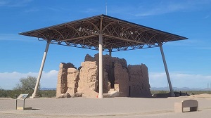
Around 1,100 BC, villages became more formally organized. Caliche homes were grouped into caliche-walled compounds, and these compounds were arranged around public plazas and public structures. The Great House was built within one of these compounds.In 1932, the Civilian Conservation Corps (CCC) built a steel shelter to protect the Great House from the harsh weather.
The summer temperatures can reach 120° F and cause cracking in the foundation. There was about a dozen members of the Youth Conservation Corps (YCC) or Native American Conservation Corps (NACC) organization that was applying caliche to the existing structures to prevent erosions.We watched several members mix the caliche while others carried buckets to apply on the surface.
There are many ancient pueblos in the southwestern United States, and this ruin is just one classic example.If you haven’t traveled through this portion of the country, be sure to check out some of the ruins along the way.
Trail: Echo Canyon Loop, Heart of the Rock Loop, Inspiration Point, Lower Rhyolite Canyon, Sarah Deming, Ed Riggs & Mushroom Rock.
We departed Picacho Peak State Park, and headed east on I-10 towards Willcox, AZ. This short-day drive is a nice section, including a brief stop at the Texas Canyon near Dragoon, AZ. There's a nice rest area to pull over for a lunch break and stretch out your legs and view the spectacular rock outcrops.
We made reservations at Grande Vista RV Park since our motorhome exceeded the maximum length of 24' at the Bonita Canyon campground in Chiricahua National Monument. Bonita Canyon campsites are primitive with no hookups. We decided to stay at the RV park with full hookups and kept our pets comfortable with the A/Cs running. It served our purpose and allow us to spend four days inside the park. This 45-minute drive each way on AZ-186 was smooth, and not much traffic along this route. It was worth the commute, and we really got to explore the park the way we intended.
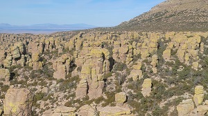
We arrived at the RV park by noon, and decided to spend a few hours at Chiricahua NM. Our purpose was to gather info and get a feel for the lay of the land. As we drove towards the park, we noticed the snowy mountains at Coronado National Forest! It seems so odd in a desert landscape. But what's even more strange are these mammals that are native of South America!!! Just as we rolled into the visitor center parking lot, we saw a large family of coatimundis or coatis. This is a first sighting of its kind for us. The rock columns are so different in this landscape. It's not what you would expect to see hiding on the other side of the mountain. Over the next three days, we hiked the Echo Canyon, Heart of the Rocks, and Inspiration Point trails.
The Echo Canyon Loop consists of three connecting trails from Echo Canyon to Hailstone to Ed Riggs trails. This rhyolite canyon tuff comes in a variety of formations: spire, column, pinnacle, and hoodoo. The Chiricahua Apache call these pinnacles “standing up rocks.” Along this loop, we passed through the Grottoes, Wall Street, Echo Park, Spherulites and more. There was always something to look at around every turn. Often, we would have to stop and turn around to see what we missed behind us. We hiked for almost two hours before we saw the first person. It felt like we had the canyon to ourselves. The hike took us about three hours and covered just over six miles to complete. We didn’t see any coatimundis but did get a close-up view of the Mexican Jay and Spotted Towhee.
Next was the Heart of the Rocks Loop. This consists of the Lower Rhyolite Canyon, Sarah Deming, and Heart of the Rocks trails. It took us five hours and 8.66 miles to complete, with a lot of hip-busting rocks to step up and down. We started from the visitor center and hiked all uphill to the top. First we entered the forest covered canyon, and then transitioned to more opened, but rocky section. Then it was all rock columns around the Heart of the Rocks Loop Trail. We saw some of the prominent rock formations like the Big Balanced Rock, Pinnacle Balanced Rock, Old Maid, Camel's Head, Thor's Hammer, Punch and Judy, Duck on a Rock, and Kissing Rocks. This was a great hike but well worth the effort. On our return hike, it was all downhill and that itself was a nice reward. Overall, this was a fabulous day with cooler weather and partly cloudy sky. A perfect hiking experience!
Lastly, we completed the Inspiration Point hike. This round-trip hike consists of Ed Riggs to Mushroom Rock to Inspiration Point trails. It took about four hours and 6.80 miles to complete. In all, we hiked 21.6 miles over three days and covered most of the interior trails of the park. There was one prominent feature called the Mushroom Rock. The Inspiration Point provided a nice aerial view of the rhyolite rocks below. We sat by the edge for a while and just soaked in the view.
This has been an enjoyable visit at the park for both of us. We would definitely come back again. And you should stop by if given the opportunity.